Hiking in the Haute Giffre – Mountain Refuges
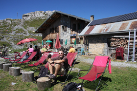
The mountains surrounding the Giffre valley are populated by numerous refuges. The refuges provide both over-night accommodation for those looking to venture further afield on multi-day hikes but are also ideal targets for those on shorter walks keen to sample delicious homemade mountain fayre for lunch.
Below are the details of a number of the refuges in the area with some ideas of suggested itineraries.
Maps and walking guides are available at the chalet for you to review and we’re always happy to suggest and recommend walks depending on your requirements and level of ability.
Refuge de la Golèse
The Refuge de la Golèse (1,660m) is nestled into the upper alpine pastures of the Col de la Golèse and affords magnificent views across the Giffre Valley.
The refuge offers accommodation for up to 80 people (dormitory and private rooms) and also offers a number of meal options for those either staying over-night or for day walkers.
Access: Parking is available at Les Alllamands – just a few minutes drive from the chalet
The walk: The refuge is a 1 hour 30 minute walk from the car park with a total climb of 600m
Suggested Itinerary: It is possible to combine a walk to the Refuge de la Golèse with a loop-track walk that also includes the Refuge de Boston-Torney (a 45 minute walk from the Refuge de la Golese) and returns to the parking at Allamands (a 75 minute decent from the Refuge de Boston), making a total walk of 3 hours 30 minutes.
Web: www.refuge-golese.com Tel: +33 4 50 90 59 53 Email: info@refuge-golese.com
Refuge de Bostan
At 1,763m in the Valley de Bostan the Refuge de Bostan has stunning views of the Dents d’Oddaz and the spectacular Dents Blanches (White Teeth), a jagged limestone ridge which remains snow capped for most of the year. The refuge is open in both the summer and winter seasons when it is accessible by snow-shoe.
The refuge offers accommodation for up to 70 people (dormitories of between 5 and 12 people) and also offers a number of meal options for those either staying over-night or for day walkers.
Access: Parking is available at Les Alllamands – just a few minutes drive from the chalet
The walk: The refuge is a 2 hour walk from the car park with a total climb of 700m.
Suggested Itinerary: It is possible to combine a walk to the Refuge de Bostan with a loop-track walk that also includes the Refuge de la Golèse. (See details above).
Web: www.refugedebostan.fr Tel: +33 4 50 90 10 94 E-mail: refuge.bostan@gmail.com
Refuge du Folly
In the Valley de Folly the Refuge du Folly at 1,560m offers striking views of the Pointe de Tuet, the Dents D’Oddaz and the Valley de Latay.
The refuge offers accommodation in both large dormitories and in smaller private rooms of between 3 and 5 people. The refuge offers a wide selection of meal options for those either staying over-night or for day walkers with the focus being on using home-grown and mountain foraged produce.
Access: There are 2 possible starting points, Pied du Crêt and Parking du Crêts, both with parking on the road prior to the village of Les Allamands, just a few minutes drive from the chalet.
The walk: Depending on the start point the walk to the refuge is either a 1 hour 45 minute or a 2 hour walk with a total climb of 600m.
NOTE: The route from the Parking du Crêts involves climbing an area of the Tuet via a track supported by hand cables cut into the rock and is therefore not suitable for those that suffer from vertigo.
Suggested Itinerary: An ideal stopping-off point for those heading to the Lac des Chambres and / or to Pointe de Bellegarde (2,514m).
Web: www.refuge-du-folly.fr Tel: +33 4 50 90 10 91 E-mail: refuge-du-folly@9online.fr
Refuge de la Vogealle
Located at over 1,900m in the Sixt Fer à Cheval Natural Reserve the refuge offers stunning views over Grand Mont Ruan (3,044m) and the Ruan and Prazon glaciers as well as the Tenneverge Massif.
Open from mid-June to the end of September the refuge offers accommodation for 58 people in small dormitories of between 6 and 10 people. The refuge offers a selection of meal options for those either staying over-night or for adventurous day walkers.
Access: The Refuge de la Vogealle can either be reached as an extended walk from the Refuge de Folly (see details above) or, more typically, from the stunning Cirque du Fer à Cheval at Sixt.
The walk: From the parking at the Cirque du Fer à Cheval there are two routes – one with an ascent time of 3 hours 15 minutes with a total climb of 950m which involves a short section with hand cables cut into the rock (not suitable for those that suffer from vertigo) or an alternative route of about 4 hours 30 minutes which takes you to the Bout du Monde and rises from there. Both walks start from the same place but diverge at the small café Buvette de Prazon.
Both routes pass the Chalet Buvette du Boret which makes an ideal mid-way stop for a drink and to admire the breath-taking upper alpine pastures.
Suggested Itinerary: By combining an ascent and decent using both of the routes described above hikers have a stunning loop track of around 7 hours that can be walked over 2 days with an overnight stay at the Refuge de la Vogealle.
Web: www.refugedelavogealle.com Tel: + 33 6 20 60 91 40 E-mail: contact@refugedelavogealle.com
Refuge de Grenairon (Chalet Hotel Buet)
Situated at over 1,974m this refuge occupies a magnificent position with plenty of outdoor seating from which to admire the Pointe de Sales (2,497m), the Rochers des Fiz and, further afield, Mont Blanc (4,810m). The refuge is often used as a resting point for those looking to climb Mont Buet (3,100) but given its proximity to the Sixt Passy National Reserve the refuge also provides an ideal spot for watching the abundant wildlife of the area including ibex, eagles and even vultures!
In the summer the refuge is open from early June to the end of September and offers dormitory accommodation for over 80 people. The refuge offers a selection of meal options for those either staying over-night or for day walkers with a focus on locally foraged products – the Tarte aux Myrtilles is a must! From October to May the refuge can accommodate up to 10 people on a ‘fend for yourself’ basis!
Access: In July and August walkers can pick-up the track from the top of the Vagnys chair lift in Salvagny, otherwise the track starts from the bridge of Nant Sec just beyond the village of Salvagny, a 10 minute drive from the chalet.
The walk: From Salvagny the refuge is a 3 hour 30 minute walk that climbs a total of around 1,100m. The walk is halved for those starting from the top of the Vagnys chair lift.
Suggested Itinerary: A loop track of around 6 hours (4 hours 30 minutes if accessed via the chairlift) incorporates the ascent mentioned above with a return via the forest of La Grand-Joux prior to returning to the village of Salvagny.
Web: www.grenairon.com Tel: + 33 04 50 34 47 31 E-mail: contact@grenairon.com
Refuge de Sales
The Refuge de Sales at 1,877m sits on the edge Le Grand Pré, a huge upper alpine meadow, between the peaks of Pointe de Platé (2,554m) and Pointe d’Anterne (2,733m).
In the summer the refuge is open daily from early June to the end of September, although, weather permitting the refuge sometimes opens at weekends during May and early October. Accommodation is offered in dormitories for up to 60 people. The refuge offers a selection of meal options for those either staying over-night or for day walkers.
Access: The stone track starts from the village of Le Lignon at the end of the road to the Cascade du Rouget that leads out of the village of Sixt, a 10 minute drive from the chalet.
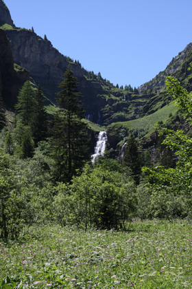
The walk: From the parking at Le Lignon the refuge is about 2 hours away with a climb of around 700m. After an initial climb the track follows the Gorges des Sales where the mountain water feeds a number of stunning waterfalls, including La Sauffaz, La Pleureuse and the magnificent Cascade du Rouget.
Suggested Itinerary: There are a number of walks that can be taken from the Refuge de Sales including the peaks of Pointe de Sales (2,497m) – 2 hours, Pointe D’Anterne (2,733m) – 3 hours and Tête Pelouse (2,475m) – 2 hours 30 minutes.
Web: www.refugedesales.com Tel: +33 4 50 34 47 01 E-mail: refugedesales@orange.fr
Refuge Alfred Wills (Anterne)
Located at 1,810m the refuge occupies the site of an old chalet (Nid d’Aigle – Eagle’s Nest) originally established in the 1850s by Alfred Wills, an Englishman who founded the Alpine Club.
The refuge is open daily from mid-June to mid-September with dormitory style accommodation for 53 people in rooms of between 2 and 10 people. The refuge offers a couple of meal options for those either staying over-night or for day walkers. The refuge is also available as a shelter in the off-season on a ‘fend for yourself’ basis.
Access: The stone track starts from the village of Le Lignon at the end of the road to the Cascade du Rouget that leads out of the village of Sixt. The route follows the same track as for the Refuge de Sales before heading off in the direction of the Collet d’Anterne.
The walk: From the parking at Le Lignon the refuge is about 3 hours away with a climb of around 770m.
Suggested Itinerary: For those looking for a full day walk (or potentially combining a walk with an overnight stop) you can take a loop track that takes in the Refuge Alfred Wills before crossing the Bas du Col d’Anterne to the Refuge des Fonts (2 hous 30 minutes). From the Refuge des Fonts (see details below) the track follows the river Giffre des Fonts before returning to Le Lignon (45 minutes). The total loop track takes about 6 hours 15 minutes.
Web: www.refuge-wills.com Tel: +33 06 70 63 12 45 E-mail: reservation@refuge-wills.com
Refuge des Fonts
The Refuge des Fonts is located at 1,360m and is situated in the stunning Cirque des Fonts just south of the Cirque de Fer à Cheval and offers fantastic views of Mont Buet (3,109m).
The refuge is open daily from mid-June to mid-September with 3 dormitories of between 9 and 14 people offering accommodation for up to 32 people. The refuge can be booked by appointment from mid-May through to late autumn.
The refuge offers a number of meal options for those either staying over-night or for day walkers. They are also happy to prepare picnics to take away for those on multi-day hikes.
Access: The track can either be started from the outskirts of the village of Salvagny or you can reduce the length of the walk by starting from the village of Les Fardeley, just beyond Le Lignon.
The walk: From Salvagny the ascent is 2 hours with a climb of 440m but has the advantage of taking in the Cascade du Rouget. The easier walk from Les Fardeley is only 1 hour 15 minutes with a climb of just over 300m.
Suggested Itinerary: See the suggested itinerary under the Refuge Alfred Wills above.
Web: www.lesfonts.com Tel: + 33 4 50 34 12 41 E-mail: didier.mogenier@wanadoo.fr
Refuge de Moëde-Anterne
The refuge, at an altitude of 2,000m, is situated in the heart of the Sixt Passy National Reserve and has tremendous views over the Mont Blanc mountain range.
The refuge is open daily from the beginning of June until the end of September with a large number of dormitories offering accommodation from 4 to 10 people up to a maximum of 110 people. The refuge offers a number of meal options for those either staying over-night or for day walkers.
Access: The stone track starts from the village of Le Lignon at the end of the road to the Cascade du Rouget that leads out of the village of Sixt. The route follows the same track as for the Refuge Alfred Wills before then passing Lac d’Anterne and the Col d’Anterne (2,257m) which sits in the shadow of the 2,459m peak of Tête de Moëde.
The walk: Not really meant as a day walk the Refuge de Moëde-Anterne is around 5 hours from the start at Le Lignon, but more normally is used as a stopping off point on multi-day walks including the impressive Les Tour des Fiz (see details below).
Suggested Itinerary: See Les Tour des Fiz below.
Web: www.monrefugepaysdumontblanc.com Tel: + 33 4 50 93 60 43
Refuge de Platé
The refuge is located at 2,032m in the heart of the Déssert de Platé, just south of the village of Flaine, a 15km2 pavement of limestone rock scarred with numerous crevasses and fissures created by acidic water run-off.
The refuge is open daily from the beginning of June until the end of September with dormitory accommodation for up to 35 people. In addition, the refuge has a number of tents available on the terrace . . . recommended for snorers! The refuge offers a number of meal options for those either staying over-night or for day walkers. The speciality of the refuge is their apricot tart!
Access: The Refuge de Platé can be accessed either via the track to the Refuge de Sales (see details above) or from the village of Flaine.
The walk: Walking from Le Lignon (5 hours 30 minutes), the refuge is not really meant as a day walk but can be combined with an overnight stop at the Refuge de Sales or as part of Les Tour des Fiz (see details below). During the months of July and August the Refuge de Platé can be reached in around an hour from the top of Les Grand Platières lift that can be taken from the centre of Flaine.
Suggested Itinerary: See Les Tour des Fiz below.
Web: www.refugedeplate.fr Tel: + 33 4 50 93 11 07 E-mail: refuge.deplate@yahoo.fr
Le Châtelet d’Ayères
The chalet is located at 1,425m and is open in both summer and winter with accommodation provided in small rooms of between 2 and 4 people. The refuge prides itself on the cuisine on offer combining the best of Haute Savoie with a strong influence from the Aosta Valley just across the Italian boarder.
Access: From the Giffre Valley access to Le Châtelet d’ Ayères is via the track for the Refuge de Platé (see above). Alternatively, from the L’Arve Valley (near Passy on the way to Chamonix) Le Châtelet can be reached from either of the villages of Plaine Joux or Le Mont.
The walk: The walk from the top of Les Grand Platières in Flaine is around 3 hours 30 minutes and initially follows the track to the Refuge de Platé before passing through the village of Plaine Joux and then past Lac Vert.
From the paragliding area at Plaine Joux in the L’Arve Valley the walk follows part of the Tour du Pays du Mont Blanc and only takes around 45 minutes. From the parking in the village of Le Mont the walk is just over 1 hour.
Suggested Itinerary: Hikes to Le Châtelet d’ Ayères can either be taken as shorter day walks or as part of multi-day hikes such as Les Tours des Fiz (see below)
In the winter season (mid-December to the end of March) Le Châtelet is accessible by foot, snow-shoe or ski from either Plaine Joux or Le Mont and is open daily for lunch with evening meals available on a request basis. Access times vary depending on the snow conditions.
Web: http://lechateletdayeres.pagesperso-orange.fr/topic/index.html Tel: +33 4 50 58 85 32
E-mail: lechateletdayeres@wanadoo.fr
Refuge de Varan
This refuge is located at 1,620m under the majestic peak of Aiguille de Varan (2,544m) in the Arve Valley (on the road to Chamonix) and accommodates 30 people in 2 dormitories and is open daily from the beginning of May to the end of September. The refuge offers a number of meal options for those either staying over-night or for day walkers.
Access: The refuge is most easily accessed from Plateau d’Assy, just above the town of Passy in the valley L’Arve, but can also be included in walks from the Refuge de Platé and Le Châtelet d’Ayères as part of Les Tour des Fiz (see details below).
The walk: Starting from the parking at the Tourist Office in Plateau d’Assy the walk to the Refuge de Varan is around 2 hours and climbs about 600m
Suggested Itinerary: The Refuge de Varan is an ideal base for experienced climbers looking to scale the Aiguille de Varan (2,544m) – 3 hours 30 minutes. In addition, with 3 paragliding take-off zones within a few minutes walk of the refuge, the Refuge de Varan is also popular with paragliders and spectators alike. The refuge is also on the multi-day walk Le Tour des Fiz described in more detail below.
Web: http://varan.tourdesfiz.com/ Tel: + 33 4 50 93 61 98
Les Tour des Fiz
For those looking to experience some of the most stunning scenery and views that the region has to offer then Les Tour des Fiz might prove to be an interesting challenge. The route takes in 8 of the refuges mentioned above. More details about the route can be found on the Savoie Mont-Blanc website and accommodation can be booked via the Passy Tourist Office.
The walk predominately follows the line of the Rocher des Fiz to the North and West but also takes in the limestone architecture of the Désert de Platé, a number of spectacular upper alpine pastures rich with flora and fauna as well as numerous stunning waterfalls.
The route can be picked-up at a number of access points, the easiest being the village of Le Lignon if you are starting from the Giffre Valley, or the village of Plaine Joux if you are starting from the Valley D’Arve heading to Chamonix
There are, however, numerous possibilities to explore the region and the National Reserves of Passy and Sixt Fer à Cheval both through day and multi-day walks with something to suit all levels of ability. We’d be happy to discuss options with you and to help coordinate drop-offs / pick-ups as required where loop tracks aren’t possible.